


Spain Topo Maps
ATLOGIS Geoinformatics GmbH & Co. KG
Perihal Spain Topo Maps
+++ App Pemetaan GPS Baru +++
Mudah untuk menggunakan aplikasi navigasi GPS Luaran / Luar Talian dengan akses kepada peta topografi terbaik dan imej udara untuk Sepanyol.
Termasuk Kepulauan Balearic dan Kepulauan Canary
++ Untuk kegunaan luar talian, ciri PRO diperlukan! ++
Hidupkan Telefon / Tablet Andoid anda ke GPS luaran untuk perjalanan ke kawasan pedalaman TANPA SELANJUTAN CELL. Aplikasi ini memberi anda pilihan pemetaan yang sama seperti yang anda ketahui dari genggam GPS.
Termasuk lapisan peta PERCUMA:
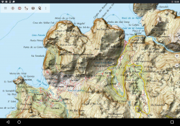
• Peta Sepanyol Topo: Peta Topográfico Nacional 1: 50.000 & 1: 25.000 (IGN MTN25 & MTN50)
• Peta Pangkalan IGN: Base Topográfica Nacional 1: 25.000 (BTN25 & BCN25)
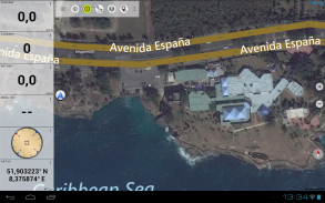
• Imagery Sepanyol: Imejan udara resolusi tinggi. Rancangan Nacional de Ortofotografía Aérea (PNOA)
• Peta Catalonia Topo: Peta topografi resolusi tinggi untuk Catalonia
• Peta Pendaftaran Tanah: Cartografía Catastral
• OpenStreetMaps: Peta-peta berbuih ini merupakan tambahan yang sangat berguna kepada lapisan peta lain. Mengandungi banyak ciri unik.
• OpenCycleMaps: Peta ini sesuai untuk merancang perjalanan basikal
• Topografi ESRI
• ESRI Aerial Images
• Peta Jalan ESRI
• Peta Jalan Google (akses dalam talian sahaja)
• Imej Satelit Google (akses dalam talian sahaja)
• Peta Google Terrain (akses dalam talian sahaja)
• Peta Bing Road (akses dalam talian sahaja)
• Imej Satelit Bing (akses dalam talian sahaja)
• Bumi Pada Malam
• Hamparan hamparan bukit
Ciri-ciri utama untuk navigasi luar:
• Buat dan edit Waypoints
• GoTo-Waypoint-Navigation
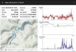
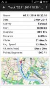
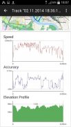
• Rakaman Rakaman (dengan profil kelajuan, ketinggian dan ketepatan)
• Tripmaster dengan medan untuk odometer, kelajuan purata, galas, ketinggian, dll.
• Eksport GPX / KML / KMZ
• Cari (nama tempat letak, POI, jalan)
• Medan data yang boleh disesuaikan dalam Paparan Peta dan Tripmaster (cth. Kelajuan, Jarak, Kompas, ...)
• Kongsi Waypoints, Tracks atau Routes (melalui eMail, Whatsapp, Dropbox, Facebook, ..)
• Koordinat paparan di Lat / Lon, UTM atau MGRS / USNG (Grid Tentera / Grid Nasional AS)
• Rakaman & kongsi lagu dengan profil statistik & ketinggian
• Putar peta (Track Up & Up Utara)
• Dapatkan Ketinggian dengan klik lama pada peta
• Track Replay
• dan banyak lagi ...
Ciri Pro yang tersedia: (Ciri-ciri Pro boleh didapati melalui Pembelian Apl)
• Penggunaan Offline - tiada perlindungan sel diperlukan
• Mudah + Fast Bulk-memuat turun jubin peta untuk PENGGUNAAN OFFLINE (bukan untuk peta Google dan Bing)
• Buat dan edit Laluan
• Laluan-Navigasi (Navigasi Titik ke Titik)
• Import GPX / KML / KMZ
• Waypoints & Tracks tanpa had
• Tambah Pelayan Tile Peta yang lain
• Tiada iklan
Penggunaan Offline:
Semua jubin peta dilihat disimpan dalam cache. Untuk cache kawasan besar anda perlu membeli ciri Pro.
Gunakan aplikasi navigasi ini untuk aktiviti luar seperti mendaki, berbasikal, berkhemah, memanjat, menunggang, bermain ski, berkanu, memburu, 4WD pelancongan luar negara atau mencari & menyelamat (SAR).
Tambah titik arah tersuai dalam garis panjang / latitud, UTM atau MGRS / USNG dengan datum WGS84.
Import / Eksport / Kongsi Laluan / Jalur Laluan GPS / Laluan dalam format GPX atau Google Earth KML / KMZ.
Pramuat data peta PERCUMA untuk kawasan tanpa perkhidmatan sel (Ciri Pro!).
Komen dan permintaan ciri untuk spainmaps@atlogis.com
Lihat aplikasi navigasi luar kami yang lain: https://play.google.com/store/search?q=atlogis
+++ Kami TIDAK menjejaki sebarang aktiviti pengguna atau mengumpul sebarang data pengguna! +++
Spain Topo Maps - Versi 7.8.0
(08-05-2025)
Spain Topo Maps - Maklumat APK
Versi APK: 7.8.0Pakej: com.atlogis.spainVersi Terkini Spain Topo Maps
Versi lain


Aplikasi dalam kategori sama


